


Geo Area - GPS Area Calculator
Описание Geo Area - GPS Area Calculator
GEO AREA measurement app is a free area and perimeter measurement app also referred to as GPS area calculator for land measurement, planimeter to measure area on map, or platometer and is used to measure field areas, collect ground samples, GIS surveys - all shareable on various GIS platforms.
WHAT MAKES GEO AREA UNIQUE?
- Highly accurate area measurement and land surveyor app, verified and tested with ground data
- GIS mapping app with multiple area and perimeter units
- Ability to generate KML files
- Sharing KML for visualization on any GIS
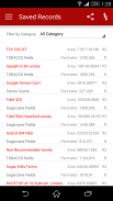
- Ability to edit, delete records
- User friendly
- Tap the map to mark area, OR
- Use the phone GPS receiver
- Ability to pause, start and stop GPS mode so that you can easily select the desired points
- Unlike our competitor Apps, Geo Area has NO RESTRICTIONS ON SHARING your data
- Not just an area calculator, its much more
AREA MEASUREMENT ACCURACY TEST EXAMPLE:
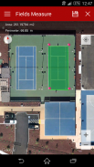
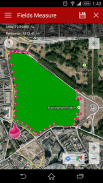
One of the screenshots shows Google Tennis Courts at (1600 Amphitheatre Pkwy,Mountain View) - check this yourself to see how accurately Geo Area works:
Tennis court dimensions are: 36 ft(10.97m) x 78 ft(23.78m)
Therefore, Area= 36 ft(10.97m) x 78 ft(23.78m)=2808 square feet(260.8666 square metres)
Perimeter = Sum of all four sides=228 ft (69.5m)
You can change units from the application settings from feet to meters OR to acres OR to hectares OR to kanals OR to kilometers. Your choice!
GEO AREA MEASUREMENT APP LETS YOU DO THE FOLLOWING:
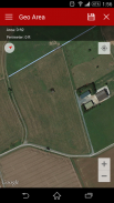
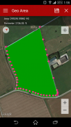
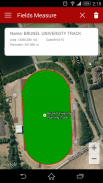
1. Measure the land area and perimeter of just about anything on the ground as seen on Google Maps
2. Use area measurement and perimeter units of your choice including feet, meter, hectare, Kanal (area units for India), kilometer, yards, and acre.
3. Either tap on the points of interest on the Google Maps to mark area, OR
4. Use the phone's GPS to mark the field boundary
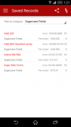
5. Create Categories of your choice where you can group fields,please refer to the screenshots
6. Create unlimited categories
7. Share and see the marked fields on any GIS for instance the Google Earth
GEO AREA MEASUREMENT APP is for:
1. Mapping and Land surveys
2. Farmers, for farm management
3. Land area measurement
4. Construction surveys
5. Agronomists
6. Town planners
7. Construction surveyor
8. GIS data collection
9. GPS fields area measure
10. Farm fencing
11. Sports track measurement
12. Construction sites and building sites area
13. Asset mapping
14. Landscape artists
Geo Area Measurement app is used by farmers for: crop yield estimation, crop area measurement, and agriculture land and area mesaurement. Geo Area has been used in conjunction with remote sensing (satellite imagery e.g. SPOT 6, SPOT 7) and GIS applications, to collect ground truth data, field records, and farm data. Geo Area measurement app is ideal for land cover analysis, vegetation mapping and remote sensing where Regions of interests (ROIs) or the Points of Interest (POIs) or Area of Interest (AOI) collected through Geo Area measurement app. As seen in the example, Geo Area is ideal for area measurement (area calculator) and perimeter of sports grounds, cricket grounds, football pitches, tennis courts, badminton courts, parking lot area, residential space, running track and rental space. Other applications of Geo area measurement app include Patwari or Patvari and the old tape-measure system for land record management.
Geo Area measurement app is also used for crop yield estimation for cotton, wheat, rice, sugarcane, maize, tobacco, Virginia, FCV tobacco, vegetables, banana plantations, dates, orchards mapping, forest mapping and GPS based area measurement of deforestation area. Geo Area measurement is also used to estimate fertilizers required for agricultural lands based on the calculated area. It is a free and simple planimeter to measure distance and land area on a map.
Nothing is complete in itself - we are learning from YOU to make Geo Area measurement app more useful. Thank you for your comments and feedback.
GEO приложение измерения площади является зона свободной и приложение измерения периметра также упоминается как GPS область калькулятор для измерения земли, планиметром для измерения площади на карте, или platometer и используется для измерения полей областей, сбор образцов грунта, обзоры ГИС - все разделяемые на различные ГИС платформы.
ЧТО ДАЕТ GEO AREA UNIQUE?
- Высокая точность измерения площади и землемер приложение, проверены и протестированы с наземными данными
- отображение ГИС приложение с несколькими области и периметра единиц
- Возможность создания файлов KML
- Совместное KML для визуализации на любой ГИС
- Возможность редактировать, удалять записи
- Удобный
- Нажмите на карту, чтобы отметить область, ИЛИ
- С помощью приемника GPS телефона
- Возможность паузы, запуск и остановка режима GPS, так что вы можете легко выбрать нужные точки
- В отличие от наших конкурентов Apps, Geo Area не имеет никаких ограничений на совместное использование данных
- Не только область калькулятор, его гораздо больше
ОБЛАСТЬ Точность измерения Пример испытаний:
Один из скриншотов показывает Google Теннисные корты на (1600 Амфитеатр Pkwy, Mountain View) - это проверить себя, чтобы увидеть, насколько точно работает Geo Площадь:
Размеры теннисного корта: 36 футов (10.97m) х 78 футов (23.78m)
Таким образом, площадь = 36 футов (10.97m) х 78 футов (23.78m) = 2808 квадратных футов (260.8666 квадратных метров)
Периметр = Сумма всех четырех сторон = 228 футов (69.5m)
Вы можете изменить единицы измерения из настроек приложения с ног до метра или в акрах или в гектарах или в kanals ИЛИ километры. Твой выбор!
GEO AREA ИЗМЕРЕНИЕ приложение позволяет вам сделать следующее:
1. Измерьте площадь земли и периметр просто ни о чем на земле, как видно на Google Maps
2. Измерение использования площади и периметра единиц вашего выбора, включая ноги, метр, гектар, Kanal (область единицы для Индии), км, ярды и акр.
3. Либо нажмите на точки интереса на Картах Google, чтобы отметить область, ИЛИ
4. С помощью GPS телефона, чтобы отметить границу поля
5. Создание категорий по своему выбору, где вы можете группировать поля, пожалуйста, обратитесь к скриншотам
6. Создать неограниченные категории
7. Доля и увидеть отмеченные поля на любой ГИС, например Google Планета Земля
GEO AREA ИЗМЕРЕНИЕ APP для:
1. Сопоставление и землеустроитель
2. Фермеры, для ведения хозяйства
3. Измерение Площадь участка
4. Строительные изыскания
5. Агрономы
6. Градостроители
7. Строительство геодезист
Сбор данных 8. ГИС
9. GPS полей мера области
10. Ферма фехтованию
11. Спорт измерения трек
сайты и строительные участки площадью 12. Строительство
13. Отображение активов
14. пейзажисты
Приложение Гео Области измерения используются фермерами для: оценок урожая сельскохозяйственных культур, измерения площади сельскохозяйственных культур и сельскохозяйственных земель и площадь mesaurement. Гео площадь была использована в сочетании с дистанционного зондирования (спутниковых изображений, например, SPOT-6, SPOT-7) и ГИС, для сбора достоверных данных, полевые записи и данные фермы. Geo Area приложение измерения идеально подходит для анализа почвенно-растительного покрова, картирования растительности и дистанционного зондирования, где Регионы интересов (Rois) или точек интереса (POI) или область интереса (AOI), собранных через приложение измерения Geo Area. Как видно на примере, Geo Area идеально подходит для измерения площади (площадь калькулятор) и периметру спортивных площадок, крикета, футбольные поля, теннисные корты, бадминтон, области автостоянка, жилой площади, беговой дорожке и аренду площади. Другие приложения Гео приложения измерения площади включают патвари или Patvari и старую систему рулетки для управления земельной записи.
Geo Area приложение измерения также используется для оценки урожайности для хлопчатника, пшеницы, риса, сахарного тростника, кукурузы, табака, Вирджиния, FCV табак, овощи, банановые плантации, даты, отображение садов, картографирования лесов и GPS измерения площади на основе площади вырубки лесов. измерение Geo Area также используются для оценки удобрений, необходимые для земель сельскохозяйственного назначения на основе расчетной области. Это бесплатный и простой планиметрировать для измерения расстояния и площади земли на карте.
Ничто не обходится в себе - мы учимся у вас, чтобы сделать Geo Area приложение измерения более полезным. Спасибо за ваши комментарии и отзывы.
GEO AREA measurement app is a free area and perimeter measurement app also referred to as GPS area calculator for land measurement, planimeter to measure area on map, or platometer and is used to measure field areas, collect ground samples, GIS surveys - all shareable on various GIS platforms.
WHAT MAKES GEO AREA UNIQUE?
- Highly accurate area measurement and land surveyor app, verified and tested with ground data
- GIS mapping app with multiple area and perimeter units
- Ability to generate KML files
- Sharing KML for visualization on any GIS
- Ability to edit, delete records
- User friendly
- Tap the map to mark area, OR
- Use the phone GPS receiver
- Ability to pause, start and stop GPS mode so that you can easily select the desired points
- Unlike our competitor Apps, Geo Area has NO RESTRICTIONS ON SHARING your data
- Not just an area calculator, its much more
AREA MEASUREMENT ACCURACY TEST EXAMPLE:
One of the screenshots shows Google Tennis Courts at (1600 Amphitheatre Pkwy,Mountain View) - check this yourself to see how accurately Geo Area works:
Tennis court dimensions are: 36 ft(10.97m) x 78 ft(23.78m)
Therefore, Area= 36 ft(10.97m) x 78 ft(23.78m)=2808 square feet(260.8666 square metres)
Perimeter = Sum of all four sides=228 ft (69.5m)
You can change units from the application settings from feet to meters OR to acres OR to hectares OR to kanals OR to kilometers. Your choice!
GEO AREA MEASUREMENT APP LETS YOU DO THE FOLLOWING:
1. Measure the land area and perimeter of just about anything on the ground as seen on Google Maps
2. Use area measurement and perimeter units of your choice including feet, meter, hectare, Kanal (area units for India), kilometer, yards, and acre.
3. Either tap on the points of interest on the Google Maps to mark area, OR
4. Use the phone's GPS to mark the field boundary
5. Create Categories of your choice where you can group fields,please refer to the screenshots
6. Create unlimited categories
7. Share and see the marked fields on any GIS for instance the Google Earth
GEO AREA MEASUREMENT APP is for:
1. Mapping and Land surveys
2. Farmers, for farm management
3. Land area measurement
4. Construction surveys
5. Agronomists
6. Town planners
7. Construction surveyor
8. GIS data collection
9. GPS fields area measure
10. Farm fencing
11. Sports track measurement
12. Construction sites and building sites area
13. Asset mapping
14. Landscape artists
Geo Area Measurement app is used by farmers for: crop yield estimation, crop area measurement, and agriculture land and area mesaurement. Geo Area has been used in conjunction with remote sensing (satellite imagery e.g. SPOT 6, SPOT 7) and GIS applications, to collect ground truth data, field records, and farm data. Geo Area measurement app is ideal for land cover analysis, vegetation mapping and remote sensing where Regions of interests (ROIs) or the Points of Interest (POIs) or Area of Interest (AOI) collected through Geo Area measurement app. As seen in the example, Geo Area is ideal for area measurement (area calculator) and perimeter of sports grounds, cricket grounds, football pitches, tennis courts, badminton courts, parking lot area, residential space, running track and rental space. Other applications of Geo area measurement app include Patwari or Patvari and the old tape-measure system for land record management.
Geo Area measurement app is also used for crop yield estimation for cotton, wheat, rice, sugarcane, maize, tobacco, Virginia, FCV tobacco, vegetables, banana plantations, dates, orchards mapping, forest mapping and GPS based area measurement of deforestation area. Geo Area measurement is also used to estimate fertilizers required for agricultural lands based on the calculated area. It is a free and simple planimeter to measure distance and land area on a map.
Nothing is complete in itself - we are learning from YOU to make Geo Area measurement app more useful. Thank you for your comments and feedback.
Geo Area - GPS Area Calculator - Версия 1.6
(04-11-2016)Geo Area - GPS Area Calculator - Информация об APK
Версия APK: 1.6Пакет: com.cegmas.geoareaПоследняя версия Geo Area - GPS Area Calculator
Другие версии


Приложения в этой категории
 4.324.074.41
Вам также могут понравиться...


